Monday, December 11, 2017

Gales Ferry Real Estate Market Report from Bridget Morrissey


The Gales Ferry Real Estate Market Report is a monthly statement of the median sales price for homes, the number of sales, the average price per square foot for homes, the number of homes for sale, and the average listing price of Gales Ferry homes for sale.


Gales Ferry is a village in the town of Ledyard, Connecticut. Gales Ferry is located along the eastern bank of the Thames River. The village developed as a result of having a ferry to Uncasville located at this site, and from which the village was named.

The Gales Ferry community has several neighborhoods, including The Village, Birdland, Christy Hills, Sherwood Forest, Glenwoods, and Presidential Estates.

The ferry which gave its name to the surrounding community of Gales Ferry was first established on the Thames in 1740. John Comstock, Ralph Stoddard, Jr. and John Hurlbut were the original three ferry men. It became known as Gale's Ferry when it was owned by Roger Gale from 1759 to 1764.

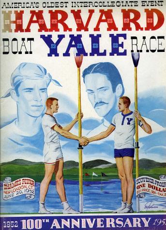
The ferry landing site at Gales Ferry (41°25′50.41″N 72°5′36.06″W) at 2 Riverside Place, is now occupied by a complex of buildings owned by Yale University which serve as a training camp for the Yale Heavyweight Men's Crew for the Harvard–Yale Regatta. The complex consists of the Varsity House, Manager's House and the Boathouse.
CLICK HERE FOR THE GALES FERRY REAL ESTATE REPORT


Sunday, December 10, 2017

Pawcatuck Neighborhoods - Clarksville


Clarks Village, or Clarksville, as it is also known, stretches from Pawcatuck Avenue by the Pawcatuck River to Greenhaven Road in Pawcatuck, a part of Stonington CT.

For information on Stonington homes for sale call or text the Bridget Morrissey Team at (860) 857-5165.


Saturday, December 9, 2017

Pawcatuck Real Estate Market Report from Bridget Morrissey


The Pawcatuck Real Estate Market Report is a monthly statement of the median sales price for homes, the number of sales, the average price per square foot for homes, the number of homes for sale, and the average listing price of Pawcatuck homes for sale.


Pawcatuck is a village in the town of Stonington which is located in New London County on the coast bordering Rhode Island. The population was 5,624 at the 2010 census. It is located across the Pawcatuck River from Westerly Rhode Island.


The Mechanic Street Historic District is on the National Register of Historic Places includes sites of shipbuilding, mills, and worker housing in a 147-acre area.

CLICK HERE FOR THE PAWCATUCK REAL ESTATE REPORT

Pawcatuck includes the neighborhoods listed below:


Thursday, December 7, 2017

Waterford Real Estate Market Report from Bridget Morrissey


The Waterford Real Estate Market Report is a monthly statement of the median sales price for homes, the number of sales, the average price per square foot for homes, the number of homes for sale, and the average listing price of Waterford homes for sale


Waterford CT is named after Waterford, Ireland. The neighborhoods are Dufree Hill, East Neck, Fog Plain, Gilead, Goshen, Great Neck, Harrisons, Lake's Pond, Logger Hill, Mago Point, Magonk, Mullen Hill, Oswegatchie, Pepperbox Road, Pleasure Beach, Ridgewood Park, Riverside Beach, Spithead, Strand, West Neck.Mago Point, Waterford, Connecticut is an area in Waterford that is home to many marine businesses such as The Dock Restaurant, the Sunbeam Fleet, Mago Point Marina, Hillyers Bait and Tackle, the Mijoy 747 fishing boat, Sunset Ribs, Mago Point Packy, and the Niantic Bay Boat Valet. Mago Point is a large tourist site, attracting people from all around the North East to Waterford.

Connecticut College Arboretum, Eugene O'Neill Theater Center, Harkness Memorial State Park, and the Waterford Speedbowl are noted area attractions.

CLICK HERE FOR THE WATERFORD REAL ESTATE REPORT


Tuesday, December 5, 2017

North Stonington Real Estate Market Report from Bridget Morrissey


The North Stonington Real Estate Market Report is a monthly statement of the median sales price for homes, the number of sales in North Stonington, the average price per square foot for homes, the number of homes for sale, and the average listing price of North Stonington homes for sale


According to Wikipedia, the rapid residential growth of North Stonington led to the development in 1963 of planning and zoning restrictions and guidelines as North Stoniongton citizens became increasingly anxious about the potential for overdevelopment destroying the rural nature of the town. Population growth in the past thirty years has continued, but at nowhere near the break-neck pace of the 1950s and 1960s; today, the main challenge to preserving North Stonington's historically rural character comes less from housing subdivisions and more from big commercial development ideas. North Stonington, because of its access to I-95, rural charm, and after 1992 its proximity to the Mashantucket casino in the adjacent town of Ledyard, has attracted numerous would-be developers who have advanced as-yet unsuccessful entertainment park schemes for the town.

North Stonington residents and visitors cherish the town for its beauty and historic value. In 1983 the village was added to the National Register of Historic Places, based on 58 existing homes and other buildings from the late 18th and early 19th centuries within the North Stonington environs.


Click here for North Stonington Real Estate Market Report